Tuesday, February 20, 2007

LG GPS phone in korea, maybe in Europe


It’s been a while since we talked about a phone with GPS feature. Today we have SB-190, which is the latest phone from LG that features an onboard GPS chip. Other features of the SB190 include 1.3MP camera, DMB receiver, and an MP3 player. TFT-LCD screen on this slide phone supports 262K colors with 240 x 320 resolution.

It looks like it’ll only be available in Korea from SK Telecom for a while and it may also hit Europe. Don’t hold your breath if you live in NA.

More info in Korean and an annoying video available here.

http://www.navigadget.com/index.php/2006/12/30/lg-sb190-cell-phone-with-gps/

Blackberry 8800 GPS navigation with NaviGadget

blackberry-8800-055.jpg


In case you haven’t heard yet, the new Blackberry 8800 from RIM has integrated GPS capabilities. Today we know that the on board GPS software is from Telenav.

What makes this BlackBerry unique is its GPS capability. We were very impressed with the bundled TeleNav GPS Navigator. For a reasonable $9.99 per month, you get spoken turn-by-turn directions (including street names), 3D maps, and local search via the Biz Finder tool. We tested the system by asking the 8800 to get us home from a park-and-ride using local roads. The very natural-sounding female voice told us the distance before the next turn and alerted us at just the right time before the turn itself. TeleNav also pulls up addresses from your contact list. The local search function worked well, too, allowing us to map a business address, navigate to it, or dial the number.


Blackberry 8800 GPS navigation -- NaviGadget

video review of new Nokia 6110 GPS navigator -- NaviGadget

Here is a video review of the new Nokia 6110 GPS navigator. The video also includes an interview with Juha P Kokkonen, director of Mobile Experiences for Nokia’s Mobile Phones business. It is a great interview if you want to learn first hand about the different GPS navigation services offered by Nokia. They also talk about the N95 and discuss which maps come free and which don’t.

video review of new Nokia 6110 GPS navigator -- NaviGadget

Sunday, February 18, 2007

GPS+GSM phone for Pet

The PetsCell™ is the first voice enabled waterproof GPS cell phone optimized for animals. It will be available for commecial distribution late in 2006 and consumer distribution in mid 2007.

Combining industry leading GPS technology with the ability of 2-way communication, the PetsCell™ delivers consistency and quality of locates across a spectrum of encompassing conditions that existing pet tracking devices simply will not match. With remote programmable geo-fence capability and an ambient temperature sensor accompanied by a variety of other attachable devices, the PetsCell™ is quite simply the standard against which all other pet tracking devices will be measured.

The PetsMobility™ PetsCell™ is the ultimate solution for lost pets.

The PetCell™ by PetsMobility™ Inc.

SiRF Deliver GPS-WiFi Hybrid Positioning

SAN JOSE, Calif. and BOSTON, Mass., February 9, 2007 – SiRF Technology Holdings, Inc. (NASDAQ: SIRF), a leading provider of GPS-enabled silicon and premium software location platforms, and Skyhook Wireless, Inc., provider of the Wi-Fi Positioning System™ (WPS), today announced that SiRF has licensed the WPS in order to create a single positioning system for wireless carriers that combines the best of both GPS and Wi-Fi technologies. This system, which is scheduled for release as part of SiRF’s Multimode Location Platform later this year, promises to boost the availability and adoption of location-based services. The two companies will present a demonstration of the new hybrid GPS/Wi-Fi location technology at the 3GSM World Congress 2007 being held February 12-15 in Barcelona, Spain.

The technology will be applied to special client software from SiRF for mobile handsets that synthesizes GPS and Wi-Fi measurements as well as to SiRF’s SiRFLoc Server to enable it to establish precise positioning from these measurements. As handset makers roll out a new generation of Wi-Fi-enabled mobile phones to enhance both data and voice communications, the SiRF-Skyhook hybrid technology will leverage this hardware ecosystem to provide greatly enhanced positioning availability and accuracy for location-based services. Using this new technology, carriers can boost their revenues by offering enhanced location-based services that are easier to use, handset makers can better differentiate their products, and application developers can create exciting new services that work anywhere, even when GPS signals are not present. The system will benefit consumers by enabling them to more quickly and reliably perform tasks such as planning a trip, finding friends nearby or locating the closest ATM machine.

“Our strategy is to enhance consumer experience with location enabled content and services by combining multiple sensors and signals to provide accurate location information everywhere. This is the first time a single positioning system has combined both GPS and Wi-Fi location data to get us a step closer to achieving 100 percent availability of accurate positioning,” said Kanwar Chadha, co-founder and vice president of marketing for SiRF. “By complementing our industry leading GPS performance with Skyhook’s Wi-Fi positioning in our Multimode Location Platform, SiRF is continuing to broaden its product line and pursue its mission to bring the benefits of location awareness to mainstream consumers.”

SiRF will be offering the new technology to mobile handset makers using SiRF’s SiRFstarIII and GSCi-5000 chips sets, as well as to wireless carriers using its SiRFLoc Server, a carrier-class, standards-compliant, multimode Assisted-GPS location server that incorporates SiRF’s patented multimode technology. Any SiRF-based mobile handset with a Wi-Fi radio subsystem built in will be able to take advantage of this new technology by including the client software.

“This partnership creates an availability breakthrough for location-based services, offering handset makers and carriers a new hybrid GPS/Wi-Fi technology for anytime, anywhere location reliability,” said Ted Morgan, founder and CEO of Skyhook Wireless. “Wi-Fi and GPS are ideal complementary technologies for mobile handsets, enabling a more comprehensive location solution and a more robust infrastructure for exciting new location-based applications.”

About Skyhook Wireless

Founded in 2003, Skyhook Wireless has pioneered the development of the first-ever metro-area positioning system that leverages Wi-Fi rather than satellites or cell towers to deliver precise location data supporting the growing market for location-based services. The Skyhook Wi-Fi Positioning System (WPS) requires no new hardware, works indoors and outdoors, provides an instant location and is more accurate than current technologies in congested downtown areas. WPS serves over 70% of the US population and is expanding internationally. Skyhook Wireless is headquartered in Boston, MA, and is privately held. Investors include Bain Capital and Intel Capital. For more information visit www.skyhookwireless.com, send email to info@skyhookwireless.com or call 617-314-9802.


Sirf press release

SiRF And OpenWave Team to Bring Advanced Location Offering to Wireless Operators

SAN JOSE AND REDWOOD CITY, Calif., February 9, 2007 SiRF Technology Holdings, Inc. (NASDAQ: SIRF), a leading provider of GPS-enabled silicon and premium software location platforms, and Openwave Systems Inc. (NASDAQ: OPWV), a leading provider of software products and services for the communications industry, today announced an alliance to accelerate the adoption of Aided-GPS location technology by wireless service providers and boost the deployment of location-based services. The two companies have worked together to integrate Openwave’s Location Manager with SiRF’s SiRFLoc Multimode location server, which Openwave has licensed and will resell globally, providing communications service providers with a robust, scalable location platform they can build upon to launch a broad range of distinctive and popular location-aware applications.

The addition of the SiRFLoc Server to Openwave’s portfolio of Adaptive Context products and solutions aims to simplify the adoption of A-GPS location technology by offering wireless carriers a “one-stop shop” for everything they need to build a location-aware infrastructure. By making it easier for carriers to adopt A-GPS, the two companies can help carriers more quickly deploy innovative, differentiated location-based services to subscribers and increase their average revenue per user (ARPU) through compelling, contextually aware content and services.

The reseller agreement enables Openwave to offer its customers a more comprehensive product portfolio for delivering accurate A-GPS location data to handsets and location applications, and provides SiRF with the opportunity to distribute its location server products through a leader in its industry. In addition to the SiRFLoc Server, Openwave will also offer the SiRF GPS Data Center, a software component required for obtaining precise GPS reference data.

“With Openwave’s industry leadership, this alliance creates exciting opportunities for SiRF to expand its location server distribution through this new channel, and we look forward to working with Openwave to address the needs of carriers as the adoption of location technology in wireless networks becomes commonplace,” said Kanwar Chadha, founder and vice president of marketing for SiRF. “Openwave’s thorough understanding of the intricacies of deploying value added services in unique operator environments will enable faster deployment of location based services through their proven, reliable infrastructure.”

SiRFLoc Server can be deployed by wireless operators or wireless application service providers, and is designed to support Multimode A-GPS (MS Assisted and MS Based) both in the control plane and in the SUPL compliant user plane architecture, as well as other advanced hybrid positioning methods. Depending on network loading, QoS and application requirements, SiRFLoc Server can dynamically mix various positioning methods and location service protocols. Taking advantage of SiRFLoc Server’s best-in-class scalability and throughput performance, operators can efficiently expand their networks as user traffic increases.

Sirf press release

smart2go: all the world’s maps for free, navigation not

smart2go-966.jpg
Nokia just announced that its mapping and navigation platform smart2go would be free for all. The platform is a hybrid map solution combining map data from Tele-Atlas and Navteq which can be downloaded directly via wireless network (e.g. GPRS/3G/WLAN) and stored on the devices memory card as needed

smart2go platform allows for mapping and routing in over 150 countries and has support for full turn-by-turn satellite navigation in over 30 countries. The application allows people to view where they are on a map, search for points-of-interests (POI) around them and create routes to get them there free of charge. Nokia plans to start offering the smart2go application for free, on Saturday, February 10th, for selected Nokia S60 and Windows Mobile 5.0 devices initially and has plans to roll out support for most of the major mobile OS platforms including Nokia S60, Series 40, PocketPC, Linux and other Windows Mobile devices.

So you’ll be able to download all the maps for free but if you want a full fledged turn-by-turn navigation system you’ll have to upgrade and buy a licence. These licenses will be available in various terms, from a week to 3 years.

When traveling to a new country for holiday one can download the relevant maps via PC in advance and subscribe to the navigation service for the duration of the holiday at affordable cost.

The free downloads will be available starting today. We have no information on the pricing yet but the sample images give us a clue:
smart2go-967.jpg

Perhaps 7.99€ per week? Oh by the way, you’ll probably need a bluetooth GPS receiver if your mobile device doesn’t have one. If you must have a brand name check out Nokia LD-1W.

GSM+GPS running shoes


A festive looking running shoe with fabulous colorful accentsMesh upper that provide the proven light weight needed to be named a fashionable high performance satellite shoe.

This hi-tech shoe comes with Quantum Satellite Technologies, GPS enabled devices locate in a hidden part of the shoes. On the right shoe you will find the emergency button on the lateral aspect and the Antennae properly positioned to locate satellite at any given time you the wearer needs any emergency help.

This product consists of the following:
GPS Antennae, Panic/Reset Buttons, DC Charger Harness Battery and other communications devices that enable the product to function effectively.

Men Orange Blue
Running

$350

Color: orange blue


Monday, February 12, 2007

Skyhook Wireless teams with SiRF for location-based services - Engadget

It's quite possible that you're at least somewhat familiar with Skyhook's ability to use WiFi in order to track down various objects, and while you've likely become desensitized to SiRF after seeing it in just about every GPS / NAV device ever produced, the two are teaming up to deliver a GPS / WiFi hybrid module for wireless carriers. Skyhook's WiFi Positioning System (WPS) will be getting a boost after inking a deal to get inside SiRF's Multimode Location Platform, which "promises to boost the availability and adoption of location-based services." The new duo will join ACCESS (among the throngs of others) at 3GSM next week in order to showcase the new technology, which is slated to provide a new level of accuracy by giving handsets the ability to find your way with two tracking protocols. Additionally, the inclusion of WiFi is said to help lock onto an initial signal much quicker than a typical standalone GPS receiver can, and if all goes as planned, we could see the hybrid technology alive and well in SiRF's Star III series of chipsets "later this year."

Skyhook Wireless teams with SiRF for location-based services - Engadget

FYI NOKIA first A-GPS handsets in the European market :Nokia's 6110 quad-band HSDPA GPS navigator

Nokia 6110 navigator,

- flaunt both GPS and HSDPA data.

- GPS and AGPS (assisted GPS)

- quad-band GSM/EDGE and UMTS 2100 for up to 3.6Mbps of hot HSDPA data.

- 2.2-inch QVGA display throwin' 16 million colors,

- 2 megapixel camera with sliding lens cover and flash,

- MicroSD expansion to augment the onboard 40MB.

- expected to ship in Q2

- pre-carrier-subsidy price of EUR450/$583

http://www.engadget.com/2007/02/12/nokias-6110-quad-band-hsdpa-gps-navigator/


Hirofumi Ide

NEC Europe Ltd.

NEC House, 1 Victoria Road, London, W3 6BL, England

Tel:+44 (0)20 8993 8111 Fax:+44 (0)20 8752 3735

DDI:+44 (0)20 8752 3875 Mobile:+44 (0)7880 786766

Email:Hirofumi.Ide@uk.neceur.com

Website:http://www.neceurope.com/

Nokia's 6110 quad-band HSDPA GPS navigator


Nokia 6110 navigator,
- flaunt both GPS and HSDPA data.
- GPS and AGPS (assisted GPS)
- quad-band GSM/EDGE and UMTS 2100 for up to 3.6Mbps of hot HSDPA data.
- 2.2-inch QVGA display throwin' 16 million colors,
- 2 megapixel camera with sliding lens cover and flash,
- MicroSD expansion to augment the onboard 40MB.
- expected to ship in Q2
- pre-carrier-subsidy price of €450/$583


http://www.engadget.com/2007/02/12/nokias-6110-quad-band-hsdpa-gps-navigator/

Thursday, February 08, 2007

Nokia Delivers Free Downloadable Maps to the Mobile World

Nokia today announced that it is making its smart2go mapping and navigation platform, available for free download ( www.smart2go.com ), enabling millions of people to use the most comprehensive map coverage offered on a mobile device. The platform allows for mapping and routing in over 150 countries and has support for full turn-by-turn satellite navigation in over 30 countries. The application allows people to view where they are on a map, search for points-of-interests (POI) around them and create routes to get them there free of charge. Nokia plans to start offering the smart2go application for free, on Saturday, February 10th, for selected Nokia S60 and Windows Mobile 5.0 devices initially and has plans to roll out support for most of the major mobile OS platforms including Nokia S60, Series 40, PocketPC, Linux and other Windows Mobile devices.

smart2go™ - Latest News

Tuesday, January 16, 2007

CSR acquires Cambridge Positioning Systems

英CSR plc.は,GPS用チップの市場に参入する。GPS用受信ICの開発に向け,NordNav Technologies ABとCambridge Positioning Systems Ltd.の2社を買収する。GPSは,携帯電話機や簡易カーナビへの搭載が,世界的に本格化しつつある。CSR社が持つRF回路の設計技術を生かし,低価 格のGPS用ICを実現することを目指す。

CSR社によれば,2007年前半の製品化を目指しており,1米ドル以下のコストを目標としている。ソフトウエア・ベースのGPS技術と位置づけて おり,CSR社のBluetooth用ICと併用し,その処理能力を一部流用することを想定する。これにより例えば,GPS機能とBluetooth機能 をともに組み込む際のBOMが,Bluetooth単独の場合に比較して1米ドル程度の上昇で済むという見方のようだ
http://www.nikkeibp.co.jp/news/flash/522702.html

-----------------------------------
CSR acquires Cambridge Positioning Systems

15 January 2007

CSR plc has acquired the assets of Cambridge Positioning Systems Ltd.

CSR today announced the company is to provide the most competitive Global Positioning System (GPS) technology for mobile handsets and network operators. CSR has acquired CPS Ltd to provide software-based low cost GPS suitable for mass-market mobile phones and PNDs (Personal Navigation Devices).

CPS, based in Cambridge, UK, has been acquired for a total cash consideration of $35 million.

For more information please see the following announcements:

Financial Announcement: CSR to deliver sub $1 GPS, acquires NordNav Technologies AB and Cambridge Positioning Systems Ltd

Trade Announcement: CSR to bring lowest cost high-performance GPS to handsets and other portable devices - target price of under $1

CSR Home Page

ends

Monday, October 30, 2006

Nokia GPS device

30 October 2006 - Nokia has launched its first dedicated satnav to come with Europe-wide maps to compete in the ever-widening personal navigation market. The Nokia 330 Auto Navigation provides seamless navigation from country to country and provides clear spoken and visual direction.

With a 3.5-inch touchscreen, 330 allows you to quickly enter addresses and follow visual instructions to your destinations. A quick address look-up provides prompted entries so that you don’t have to enter the same address time and time again.

The device comes with a 2GB memory cards with the pre-installed Europe maps, which are provided by Navteq and the Route 66 Navigate 7 application, and features a built-in GPS receiver. Visual instructions can be viewed on 2D or 3D maps, and the device can display day or night view.

It also supports the usual audio, picture, and video files. Look out for it to hit the shelves before Christmas for around €360.

Story tools continue after advert

disable ad

Monday, October 02, 2006

携帯のGPS機能を利用しているユーザーは26%

携帯のGPS機能を利用しているユーザーは26%

ネプロジャパンとネプロアイティは9月29日、「本格化するケータイナビの利用」をテーマにしたモバイルレポートの結果を発表した。調査は9月7日と8日の両日、3キャリア向けに提供している「ザ★懸賞」サイトで実施されたもので、有効回答数は3608人。

GPS付き携帯ユーザーの約半数がGPS機能を利用


 同調査によれば、携帯電話のGPS機能を利用したことがあるユーザーは全体の26パーセント。携帯電話にGPS機能が付いていないユーザーが、49パーセントで最多となり、GPS機能が付いていても、使ったことがないユーザーは25パーセントだった。


 携帯電話にGPS機能が付いていたら便利だと思うかについては、「どちらかと言えば便利」という回答が46パーセント、「とても便利」という回答が29パーセントで、便利だと考えているユーザーは75パーセントを占めた。


 GPS機能が付いていたら、どのような目的で利用したいかについては、「目的地までのナビゲーション」が69パーセント、「旅行先でのナビゲーション」が59パーセントと、ナビゲーションの利用が多くなっている。


 それ以外は、「災害時の安否・所在地確認」が48パーセント、「近隣の公共施設情報検索」と「子供や高齢者の安全確認(現在位置確認)」が共に
39パーセント、「カーナビの代わり」が36パーセント、「現在地周辺の駐車場検索」が24パーセント、「勤務中のナビゲーション(営業先確認等)」が9
パーセントと続いた。自由記述での「その他」の回答には、「浮気調査」というものも見られた。


 なお、「災害時の安否・所在地確認」と「子供や高齢者の安全確認」は5割以下となったが、2007年以降、3G携帯にGPS機能が標準搭載されれば、利用したいと考えるユーザーは増えると予測されている。


http://www.itmedia.co.jp/enterprise/mobile/articles/0610/03/news014.html


powered by performancing firefox

Wednesday, September 27, 2006

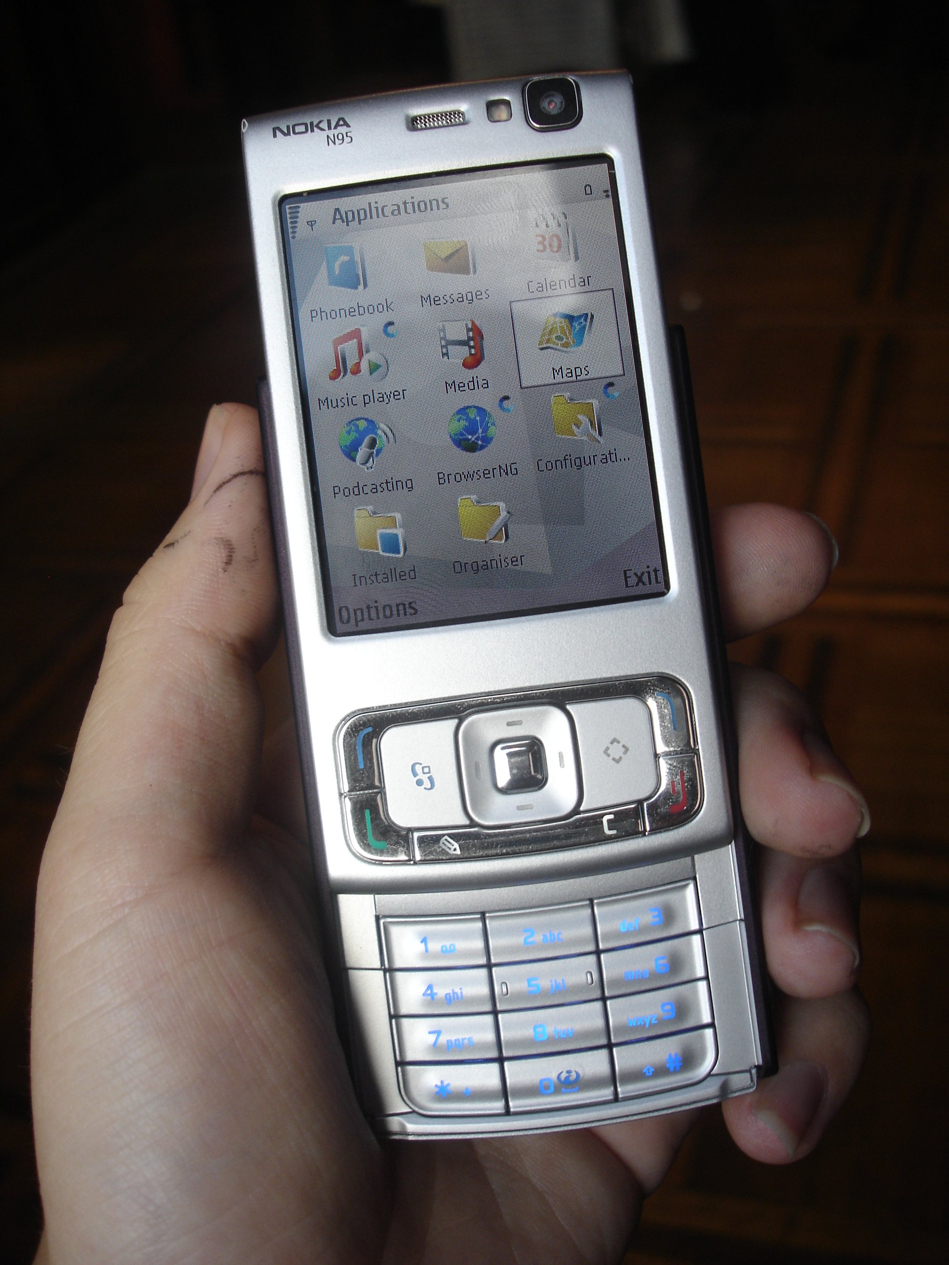
Nokia N95 GPS handset

Nokia N95 - [updated, official]


Published by Rafe Blandford at 14:20 BST, September 26th


Nokia have announced the Nokia
N95, featuring an innovative double slide design with multimedia
controls and a keypad on opposite end of the phones. Read on for full
details, pictures and the full press release.


Summary: The N95 is Nokia's first HSDPA (3.5G) device, but also boasts Wi-Fi,
WCDMA, quad-band GSM, Bluetooth (including A2DP), IrDA and USB 2.0
connectivity (via mini USB connector). Other hardware features include
a 5 megapixel camera, a built in GPS, TV-Out, 3.5mm audio jack, FM Radio, a MicroSD memory card slot and 150MB of internal memory.

In
the hand the most impressive aspect of the device, given its feature
set, is its size. At 99mm x 20mm x 53mm (90cc), the N93 packs an
impressively amount into a small space. Nokia have managed to add two
major technologies to the Nseries line (GPS and HSDPA) while
significantly reducing the volume of the device. In length and width
dimensions it is larger that the other Nseries slider - the N80, but it
is considerably thinner.

HSPDA is the next generationin
cellular connectivity. The N95 is a category 6 HSPDA device which means
it is up to 10 times faster that WCDMA (3G).
Clearly HSDPA support is required at a network level, but many networks
have already begun their testing or roll out periods. The faster
connection speeds make downloading media (such as podcasts via the in
built Podcast application) more palatable and should also improve
latency/round trip times. Wi-Fi, WCDMA (3G) connectivity, together with
quad band GSM and EDGE are also supported. Bluetooth 2.0, IrDA and USB
make up the local connectivity options.

The 5.0
megapixel camera uses Carl Zeiss Optics with autofocus and digital zoom
with a dedicated 2 stage capture button on the side of the phone. Video
capture at near DVD quality is also supported. On the side of the
device there are several buttons dedicated to camera usage. This allows
the device to be held in a similar way to a traditional camera with the
screen, in landscape mode, used as the view finder and the shutter
button on bottom right hand side of the device (top right when phone is
held horizontally). On the rear of the device, next to the camera is
the slide switch, which is used to open the lens aperture and activate
camera mode. Although it is difficult to judge the image quality at
this stage the evidence we saw suggest that the N95 will be on of the
most capable camera phones available.

N95 N95 and E50

http://www.allaboutsymbian.com/news/item/4328_Nokia_N95-HSDPA_WiFi_5MP_Camer.php


powered by performancing firefox


powered by performancing firefox


powered by performancing firefox

Tuesday, September 19, 2006

HighlyDeveloped Projette

HighlyDeveloped Projette

HighlyDeveloped Projette


http://dozo.rgr.jp/log/eid10.html

Monday, August 21, 2006

ハウジング候補

Colocation

1U

1U Special Offer

2U

4U

Numer of servers in U space

1

1

1

IPs

2

2

4

Traffic

1 Mbit

1 Mbit

1 Mbit

Power Supply Sockets

1

1

1

Setup Fee

£99

£99

£99

Monthly Cost

£139.99

£189.99

£229.99

More Information on Product

More Information on Product

More Information on Product

http://www.iws-hosting.co.uk/server-colocation.htm

KDDI New Junior handset

「A5520SAII」うみいろ

「A5520SAII」さくらいろ
 KDDIおよび沖縄セルラーは、電源をオフにするとGPSの位置情報がメールで送信される機能などを搭載したCDMA 1X端末「ジュニアケータイ A5520SAII」を9月上旬に発売する。

 今回発売される「ジュニアケータイ A5520SAII」は、子供向けの安心機能を搭載した「ジュニアケータイ A5520SA」の後継機種。GPS機能が強化され、電源がオフになると予め登録したアドレスにGPSの位置情報を記録したメールを送信する「電源オフ GPSメール」機能を新たに搭載。ブザー機能はサイドキーでも利用できるようになったほか、電池を携帯電話本体に固定する「電池ロック」が採用されてい る。なお、航空機内や病院などの場所向けに、電源OFFメニューに「完全電源OFF」機能が用意されている。

 安心機能ではこのほか、GPS機能で居場所が確認できる「安心ナビ」に対応するほか、セコムが提供する緊急通報・現場急行サービス「ココセコムEZ」、日本緊急通報サービスが提供する消防・警察への通報サービス「HELPNETケータイ」が有料で利用できる。

 発信制限や使いすぎを防止できる「ジュニアモード」「ジュニア設定メニュー」を搭載。遠隔オートロックも利用できる。主なサービスでは、着う た、声de入力対応のEZナビウォーク、Hello Messengerなどに対応。赤外線通信、スマートモード、ペア機能などが利用できる。日本語入力機能はATOK+APOT。

 メインディスプレイには約2.2インチ、240×320ドット(QVGA)の液晶ディスプレイを搭載。本体の大きさは約48×94×21mmで、重さは約105g。連続待受時間は約290時間、連続通話時間は約190分。本体カラーはうみいろ、さくらいろの2色。


電源オフGPSメールなど安心機能が充実した「A5520SAII」

Thursday, August 03, 2006

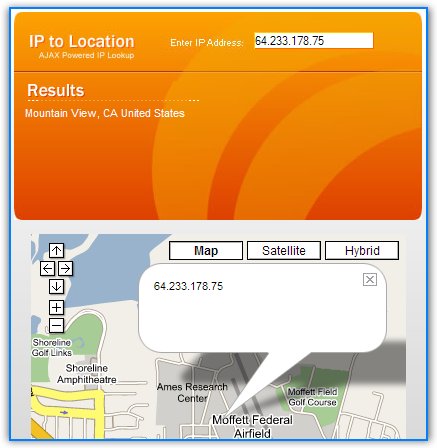
Find IP Location With Google Maps


SEOmoz has created a tool that allows you to enter an IP and to locate it on Google Maps. The application uses Ajax so it will display the map as you type (it's useful to test Class C IP ranges).

So next time you find a strange IP in your stats, or when you want to find the address of someone and you know only the IP, use this mashup. The results are not extremely accurate as there are many ways to hide the IP and many machines are behind a NAT.


Note: I'll be gone in a short vacation, but that doesn't mean I won't be around. Starting from tomorrow TomHTML from Zorgloob will keep you company. He asked me to tell you he's not fluent in English, but I'm not either.